Namibia's one-stop shop for environmental information
map
A representation, normally on a flat medium, that displays the physical and political features of a surface area of the earth, showing them in their respective forms, sizes and relationships according to some convention of representation. (Source: RHW)
The listing below shows all records tagged with this term.
The records can be filtered using the search boxes. Or leave this page and do a full search of all records.
Displaying results 1 - 50 of 168 record(s) tagged with this keywordClick/tap on any title to see full details of the record
2016. Gazetteer of place names Namibia.
Downloadable files:
| Attachment | Size |
|---|---|
| Gazetteer of place names Namibia_2016.pdf | 7.62 MB |
Map of SADC and protected areas.
Downloadable files:
| Attachment | Size |
|---|---|
| SADC and protected areas.jpg | 1.28 MB |
1983. The vegetation of Africa, a descriptive memoir to accompany the UNESCO/AETFAT/UNSO Vegetation Map of Africa (3 Plates, Northwestern Africa, Northeastern Africa, and Southern Africa, 1:5,000,000). UNESCO, Paris. The Geographical Journal 151 (1) 132-134
Website link:http://www.jstor.org/stable/633318
Interactive Digital Atlas of the Cuvelai-Etosha Basin by CuveWaters Project and GIZ.
Website link:http://www.cuvewaters.net/Digital-Atlas.113.0.html
2003. Effects of landscape characteristics on land-cover class accuracy. Remote Sensing of Environment 84 (3) 342-349
2009. Euphorbia ohiva (Euphorbiaceae), a new species from Namibia and Angola. South African Journal of Botany 75 (2) 249 - 255
2007. Geo-information pyramids for up-to-date and flexible conservation plans: A case study for Transfrontier Conservation Areas. South African Journal of Science
103 442 - 448
Downloadable files:
| Attachment | Size |
|---|---|
| Geo_information pyramids for up_to_date and flexible conservation plans.pdf | 1.53 MB |
Website link:http://hdl.handle.net/10019.1/14996
1953. Distribution of Welwitschia mirabilis. Ameriacan Journal of Botany 40 (4) 280 - 285
Website link:http://www.jstor.org/pss/2438668
Freshwater Ecoregions of the World (FEOW).
Website link:http://www.feow.org/ecoregion_details.php?eco=553
1995. Measurement and mapping of avian diversity in southern Africa: implications for conservation planning. Ibis 137 (3) 410-417
1992. Putting biodiversity on the map: Priority areas for global conservation. International Council for Bird Preservation.
Website link:https://portals.iucn.org/library/node/14866
GoogleOzi.
Website link:http://www.zubak.sk/GoogleOzi/
2001. Botswana National Atlas.
2002. QDS grid.
Downloadable files:
| Attachment | Size |
|---|---|
| QDS grid.zip | 143.89 KB |
| QDS-Fixed.kmz | 236.39 KB |
| QDS-Rollover.kmz | 236.77 KB |
1997. Mapping of biological diversity in Sahel by means of satellite image analyses and ornithological surveys. Biodiversity and Conservation 6 (4) 545 - 566
1963. Südost-Angola: Landschaft, Landschaftshaushalt und Entwicklungsmoglichkeiten im vergleich zum zentralen Hochland von mittel-Angola.
Downloadable files:
| Attachment | Size |
|---|---|
| Sudost - Angola.pdf | 4.96 MB |
2002. 5.35 Potentials for tourism.
Downloadable files:
| Attachment | Size |
|---|---|
| Fig 5.35 Potentials for tourism.zip | 143.89 KB |
2002. 5.34 Tourism accommodation - database.
Downloadable files:
| Attachment | Size |
|---|---|
| Fig 5.34 Tourism accommodation - database.zip | 143.89 KB |
2002. 5.34 Tourism accommodation.
Downloadable files:
| Attachment | Size |
|---|---|
| Fig 5.34 Tourism accommodation.zip | 143.89 KB |
2018. Metadata for the LandPKS monitoring and herbaceous biomass monitoring carried out by the Rangeland Monitoring Project.
Downloadable files:
| Attachment | Size |
|---|---|
| Rangeland Monitoring Project metadata.zip | 246.63 KB |
2013. High-Resolution Global Maps of 21st-Century Forest Cover Change. Science (342) 850-853
Downloadable files:
| Attachment | Size |
|---|---|
| High_Resolution Global Maps of 21st_Century Forest Cover Change.pdf | 4.41 MB |
2017. !Gawachab Conservancy Profile Map 2017.
Downloadable files:
| Attachment | Size |
|---|---|
| Gawachab Conservancy Profile Map 2017.jpg | 1.36 MB |
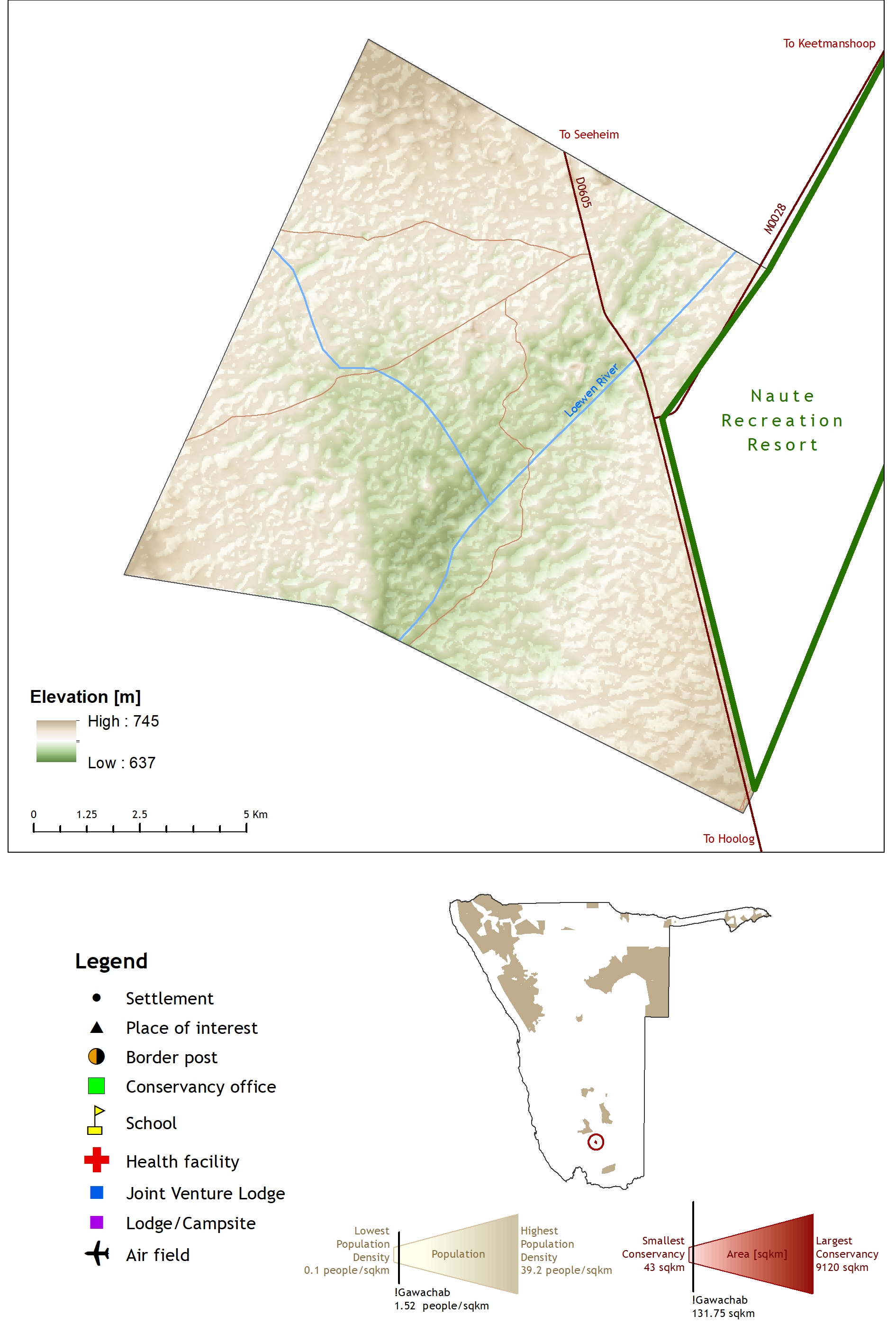
2017. !Han /Awab Conservancy Profile Map 2017.
Downloadable files:
| Attachment | Size |
|---|---|
| Han Awab Conservancy Profile Map 2017.jpg | 1.56 MB |
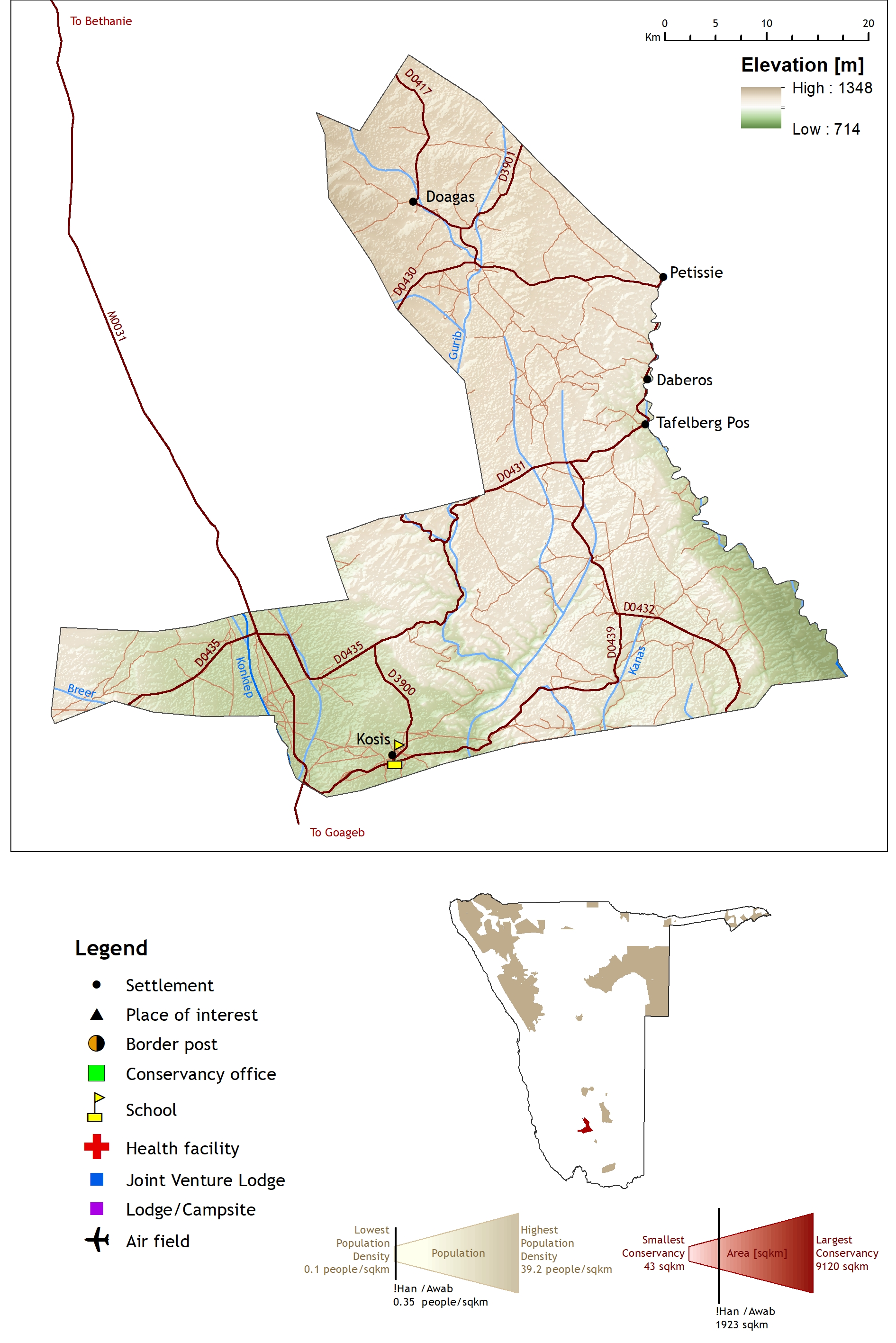
2017. !Khob !Naub Conservancy Profile Map 2017.
Downloadable files:
| Attachment | Size |
|---|---|
| Khob Naub Conservancy Profile Map 2017.jpg | 1.49 MB |
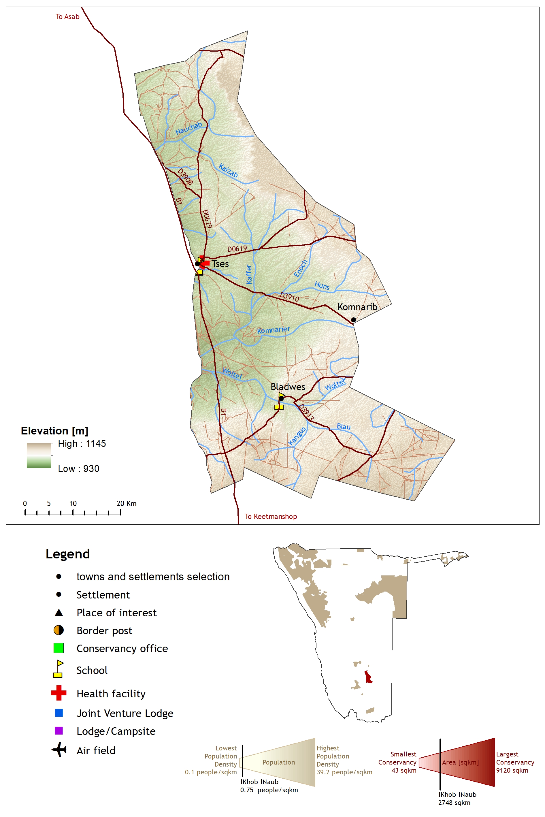
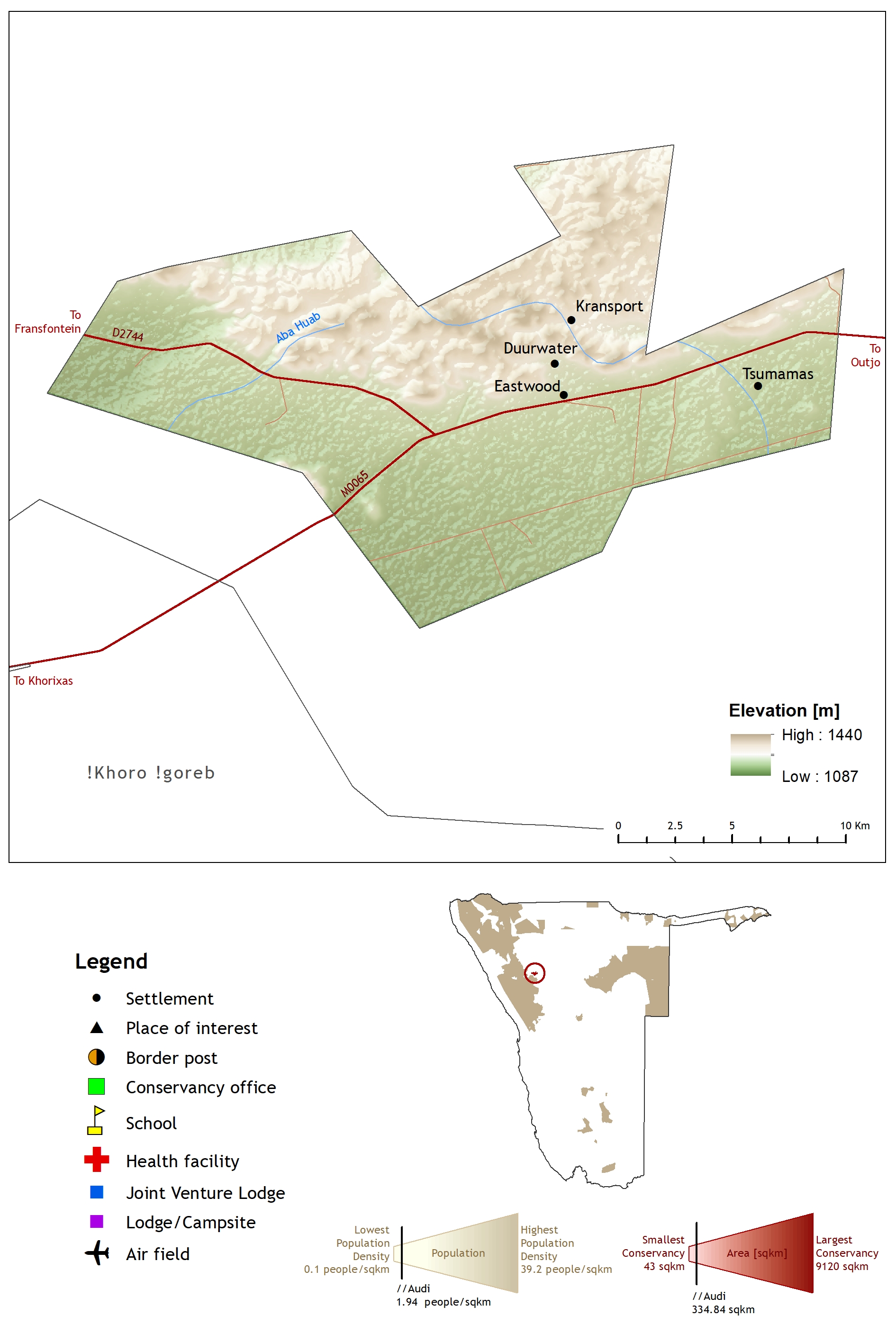
2017. !Khoro !Goreb Conservancy Profile Map 2017.
Downloadable files:
| Attachment | Size |
|---|---|
| Khoro Goreb Conservancy Profile Map 2017.jpg | 1.75 MB |
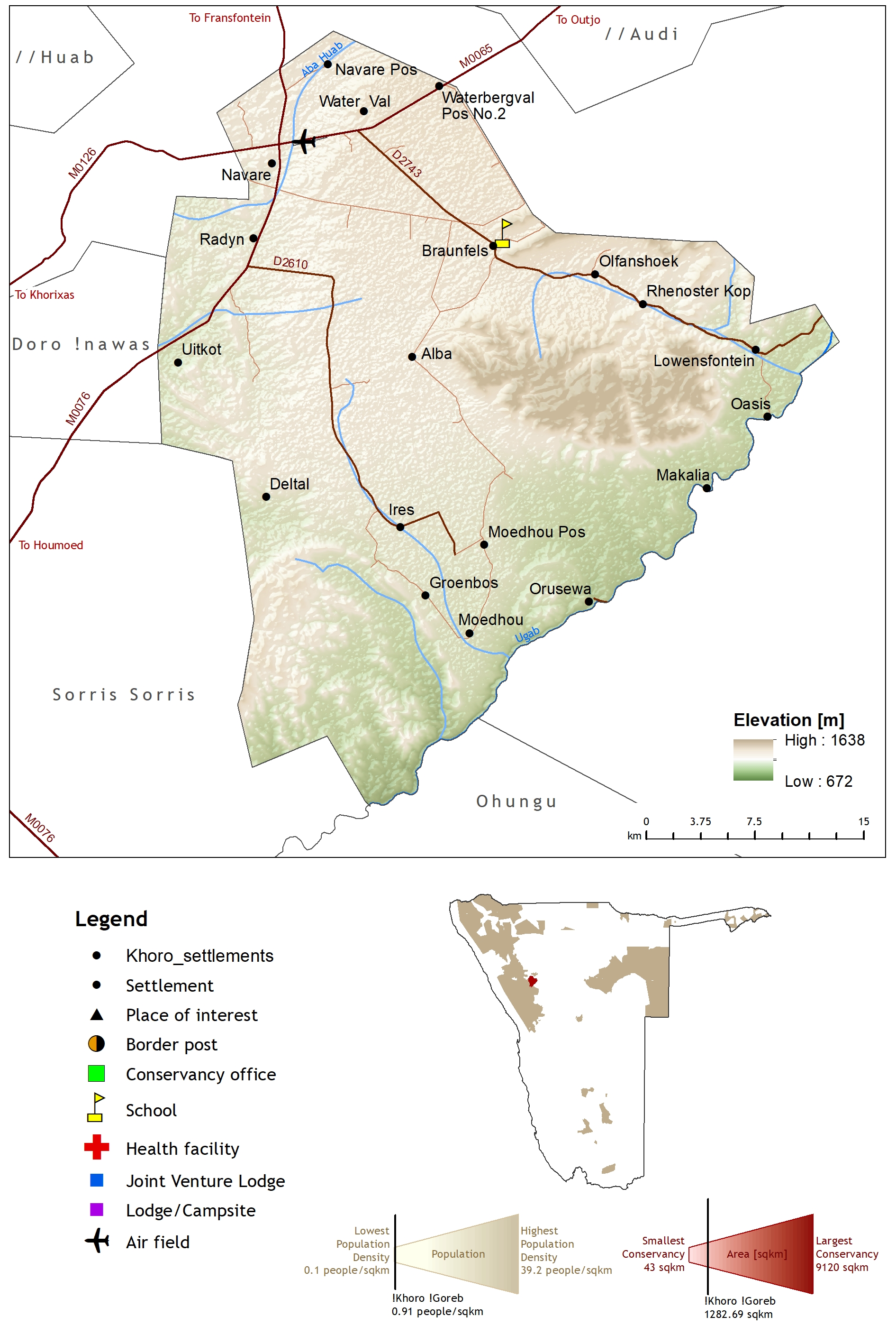
2017. //Audi Conservancy Profile Map 2017.
Downloadable files:
| Attachment | Size |
|---|---|
| Audi Conservancy Profile Map 2017.jpg | 1.14 MB |
2017. //Gamaseb Conservancy Profile Map 2017.
Downloadable files:
| Attachment | Size |
|---|---|
| Gamaseb Conservancy Profile Map 2017.jpg | 1.13 MB |
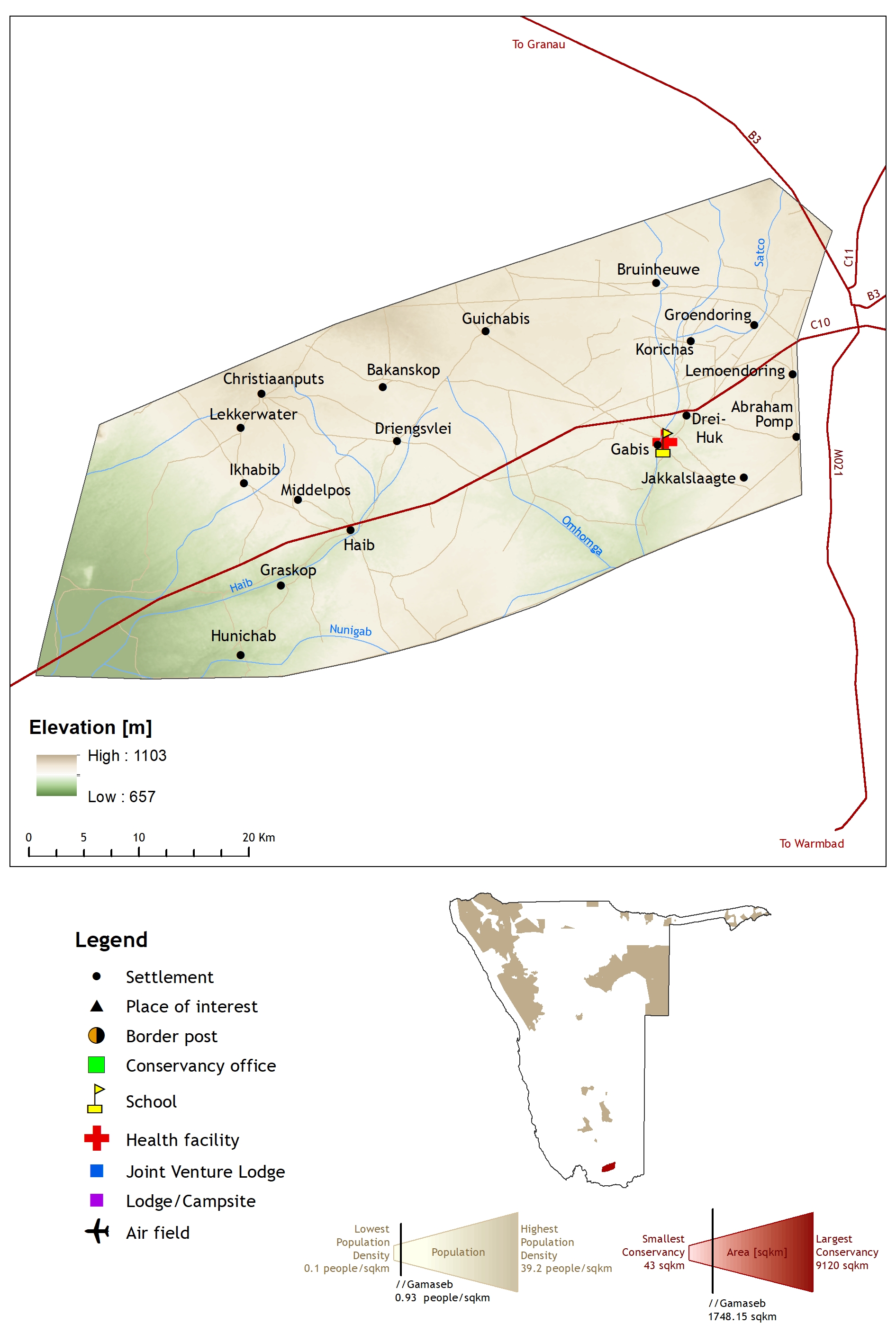
2017. //Huab Conservancy Profile Map 2017.
Downloadable files:
| Attachment | Size |
|---|---|
| Huab Conservancy Profile Map 2017.jpg | 1.81 MB |
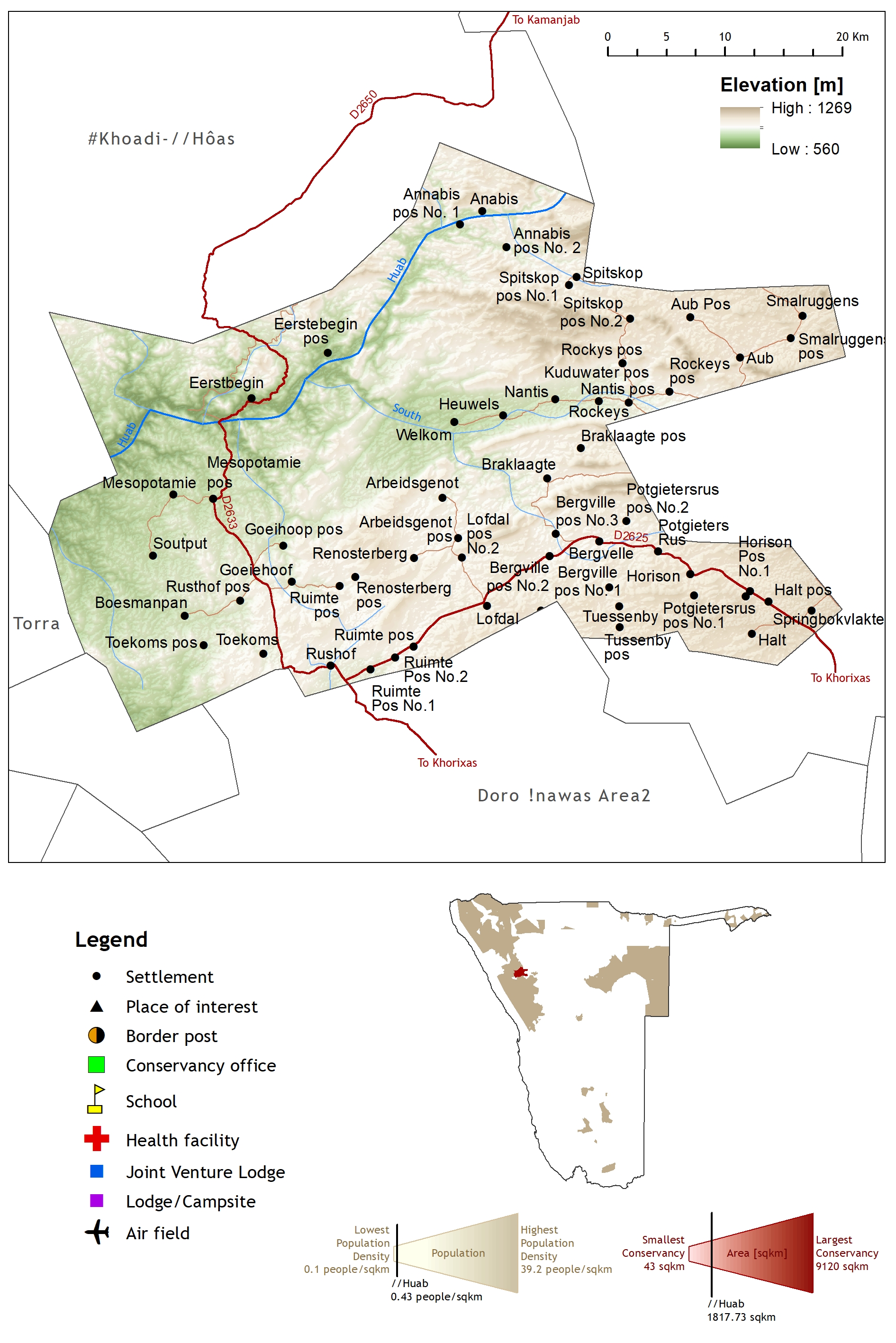
2017. African Wild Dog Conservancy Profile Map 2017.
Downloadable files:
| Attachment | Size |
|---|---|
| African Wild Dog Conservancy Profile Map 2017.jpg | 1.01 MB |
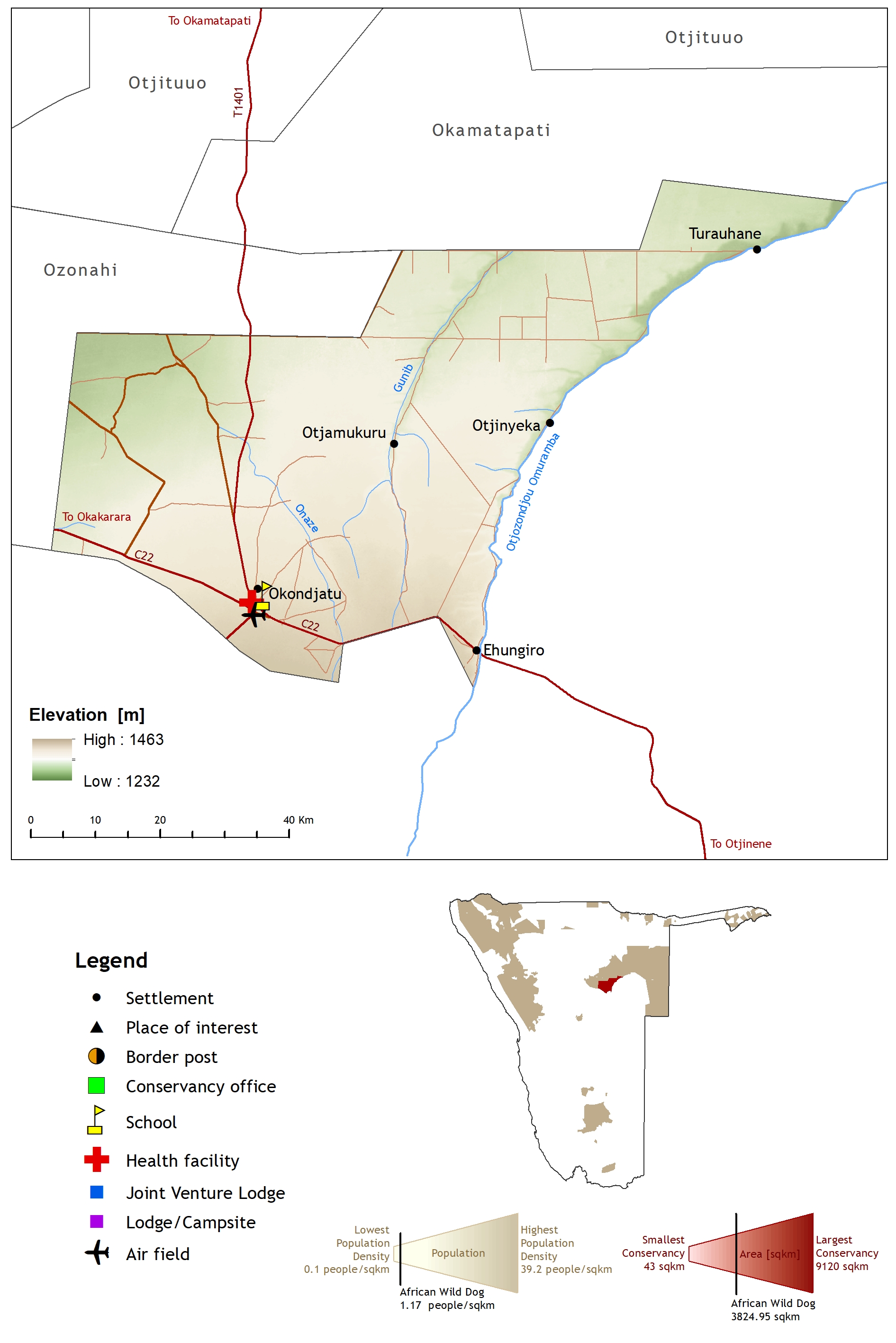
2017. Anabeb Conservancy Profile Map 2017.
Downloadable files:
| Attachment | Size |
|---|---|
| Anabeb Conservancy Profile Map 2017.jpg | 1.05 MB |
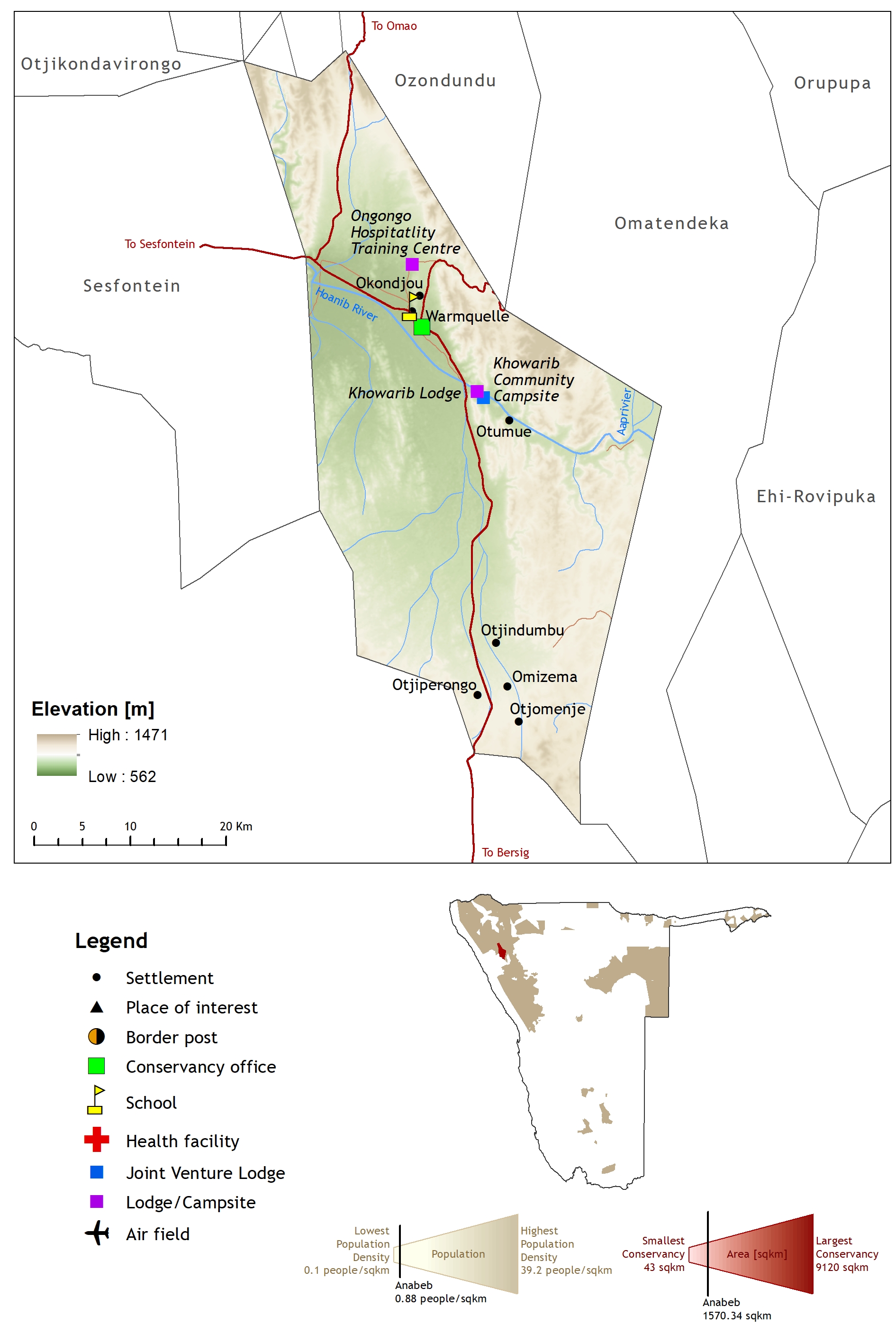
2017. Balyerwa Conservancy Profile Map 2017.
Downloadable files:
| Attachment | Size |
|---|---|
| Balyerwa Conservancy Profile Map 2017.jpg | 1.87 MB |
2017. Bamunu Conservancy Profile Map 2017.
Downloadable files:
| Attachment | Size |
|---|---|
| Bamunu Conservancy Profile Map 2017.jpg | 1.51 MB |
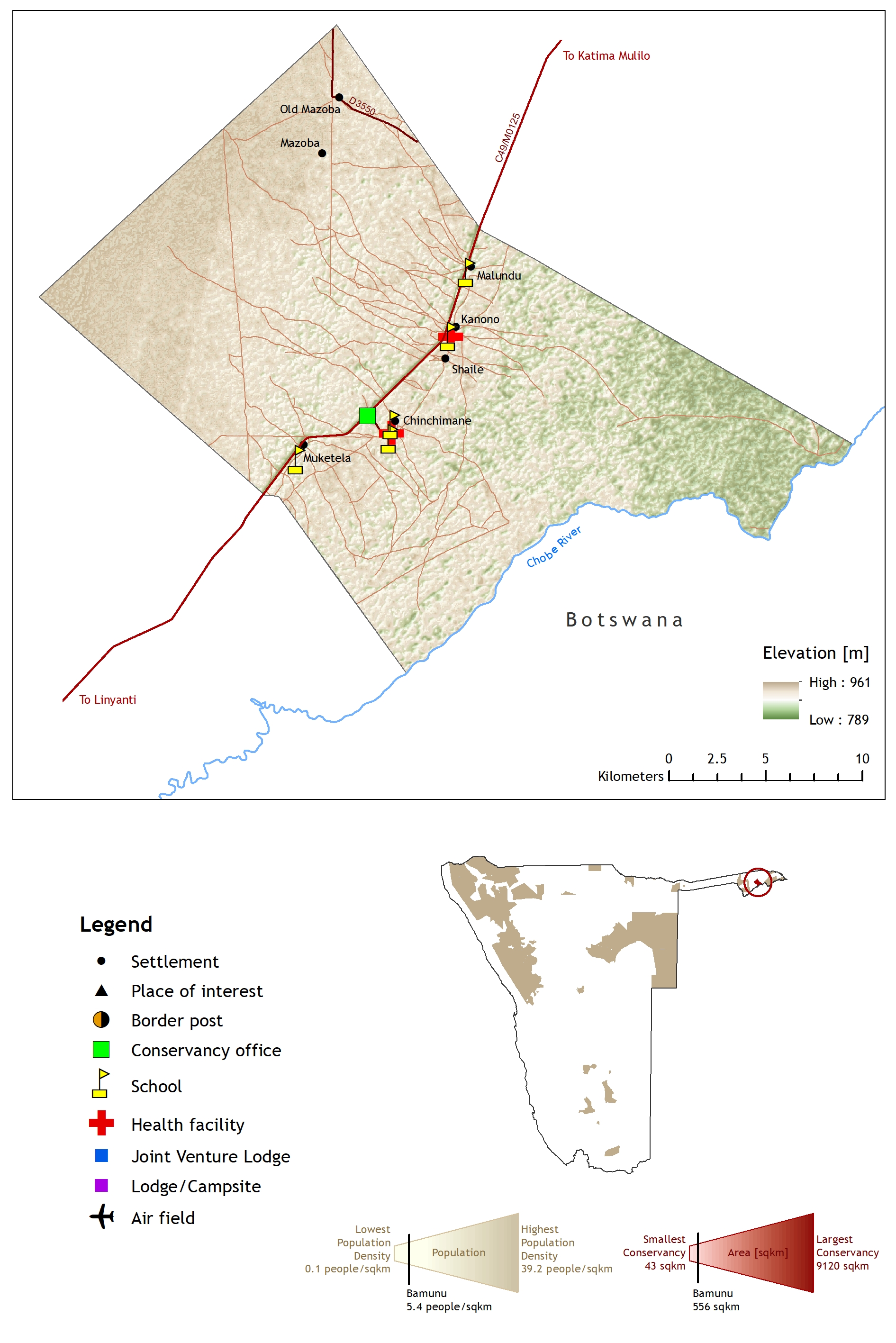
2017. Dzoti Conservancy Profile Map 2017.
Downloadable files:
| Attachment | Size |
|---|---|
| Dzoti Conservancy Profile Map 2017.jpg | 1.67 MB |
2017. Ehi-Rovipuka Conservancy Profile Map 2017.
Downloadable files:
| Attachment | Size |
|---|---|
| Ehi_Rovipuka Conservancy Profile Map 2017.jpg | 1.28 MB |
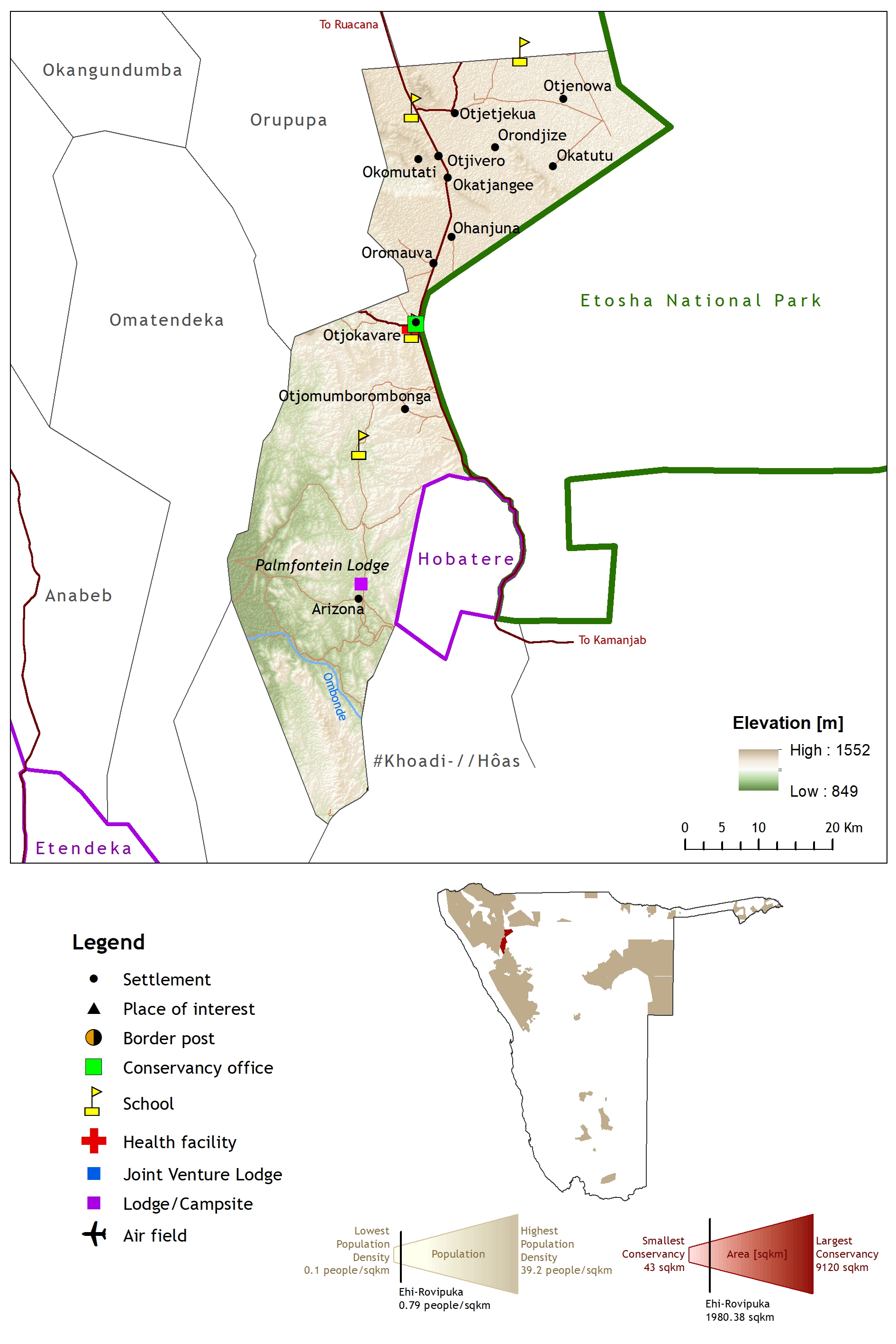
2017. Eiseb Conservancy Profile Map 2017.
Downloadable files:
| Attachment | Size |
|---|---|
| Eiseb Conservancy Profile Map 2017.jpg | 2.23 MB |
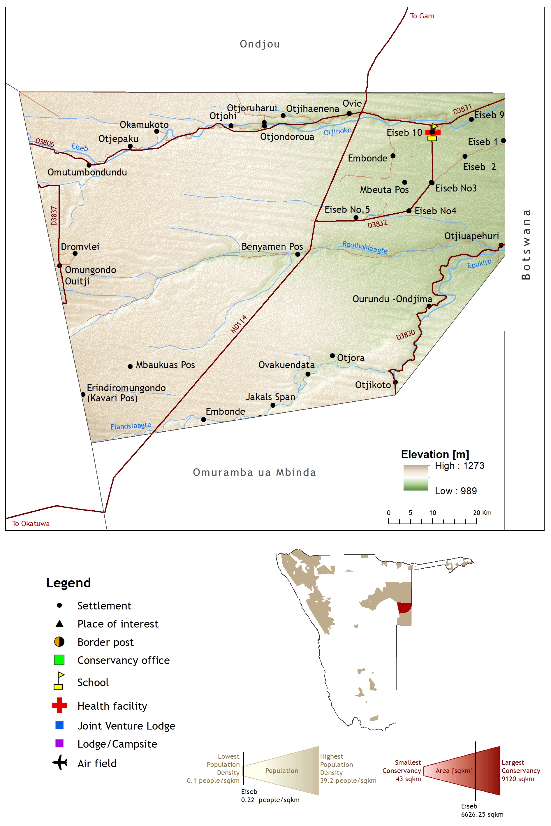
2017. Epupa Conservancy Profile Map 2017.
Downloadable files:
| Attachment | Size |
|---|---|
| Epupa Conservancy Profile Map 2017.jpg | 1.18 MB |
2017. Etanga Conservancy Profile Map 2017.
Downloadable files:
| Attachment | Size |
|---|---|
| Etanga Conservancy Profile Map 2017.jpg | 1.18 MB |
2017. George Mukoya Conservancy Profile Map 2017.
Downloadable files:
| Attachment | Size |
|---|---|
| George Mukoya Conservancy Profile Map 2017.jpg | 1.97 MB |
2017. Huibes Conservancy Profile Map 2017.
Downloadable files:
| Attachment | Size |
|---|---|
| Huibes Conservancy Profile Map 2017.jpg | 1.54 MB |